
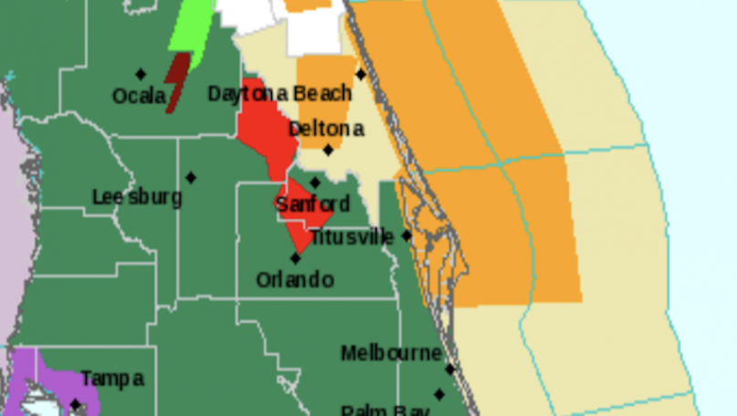
Headline Surfer multimedisa / The area in red is where a tornado warning has been issued by the National Weather Service in Melbourne, FL, primarily affecting Orlando, Altamonte Springs, Oviedo and Sanford.
By HENRY FREDERICK / Headline Surfer
SANFORD, Fla. -- The National Weather Service has issued a tornado warning for portions of East Central Florida, primarily southwestern Seminole County and North Central Orange County.
Here is the National Weather Service bulletin:
National Weather Service Melbourne FL
916 PM EDT Sat Jun 6 2020
FLC095-117-070130-
/O.CON.KMLB.TO.W.0021.000000T0000Z-200607T0130Z/
Seminole FL-Orange FL-
916 PM EDT Sat Jun 6 2020
...A TORNADO WARNING REMAINS IN EFFECT UNTIL 930 PM EDT FOR
SOUTHWESTERN SEMINOLE AND NORTH CENTRAL ORANGE COUNTIES...
At 916 PM EDT, a severe thunderstorm capable of producing a tornado
was located over Casselberry, moving northeast at 40 mph.
HAZARD...Tornado.
SOURCE...Radar indicated rotation.
IMPACT...Flying debris will be dangerous to those caught without
shelter. Mobile homes will be damaged or destroyed. Damage
to roofs, windows, and vehicles will occur. Tree damage is
likely.
Locations impacted include...
Orlando, Sanford, Altamonte Springs, Oviedo and Winter Springs.
PRECAUTIONARY/PREPAREDNESS ACTIONS...
TAKE COVER NOW! Move to an interior room on the lowest floor of a
sturdy building. Avoid windows. If you are outdoors, in a mobile
home, or in a vehicle, move to the closest substantial shelter and
protect yourself from flying debris.
Heavy rainfall may hide this tornado. Do not wait to see or hear the
tornado. TAKE COVER NOW!
Tornadoes are extremely difficult to see and confirm at night. Do not
wait to see or hear the tornado. TAKE COVER NOW!
&&
LAT...LON 2879 8143 2879 8142 2881 8141 2867 8118
2851 8135 2863 8142 2871 8148
TIME...MOT...LOC 0116Z 219DEG 36KT 2868 8134
TORNADO...RADAR INDICATED
HAIL...0.00IN