
 By HENRY FREDERICK / Headline Surfer
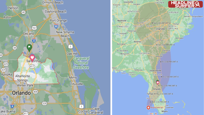
ORLANDO, Fl. -- A Hurricane Warning remains in effect for East Central Florida, according to the National Weather Service in Melbourne.
Hurricane Ian is nearing landfall as one of southwest Florida's most intense hurricanes on record, expected to produce catastrophic storm surge, destructive winds, and flooding rainfall.
Ian is a Category 4 hurricane packing maximum sustained winds of 155 mph as of 10 a.m. EDT Wednesday morning.
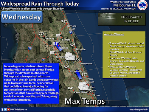
• Peak Wind Forecast: 50-65 mph with gusts to 85 mph.
The window for tropical storm force winds is early this afternoon until Thursday evening.
Potential for wind 74 to 110 mph - The wind threat has increased from the previous assessment.
• Plan for a life-threatening wind of equivalent CAT 1 or 2 hurricane force.
Be Prepared: Remaining efforts to protect life and property should be urgently completed. Prepare for considerable wind damage.
CITY           SKY/WX    TMP DP  RH WIND       PRES   REMARKS
ORLANDO INTL   LGT RAIN  75  73  93 E9        29.82R
DAYTONA BEACH  LGT RAIN  77  74  90 E12G20    29.84F
KSC            RAIN      75  68  78 E18G29    29.82R
CAPE CANAVERAL RAIN      75  72  88 E16G30    29.81R
TITUSVILLE     RAIN      79  73  83 E22G29    29.85R FOG
SANFORD        LGT RAIN  74  73  97 E13       29.83R
DELAND         LGT RAIN  74  73  96 NE8       29.85S
NEW SMYRNA BCH LGT RAIN  77  73  88 E17G30    29.84F
ORMOND BEACH   LGT RAIN  75  75 100 NE13G21   29.84F
Some coastal gauges are now reporting water rises, the beginning of Ian's storm surge, in Napleds. Meanwhile, winds blowing offshore have produced a blowout tide in Tampa Bay Wednesday morning.
Bands of heavy rain containing strong wind gusts are lashing parts of the Florida Peninsula and the Florida Keys right now.
Winds have recently gusted up to 62 mph in Ft. Myers and Naples. Gusts over 40 mph have been clocked on the Atlantic side in Melbourne. Street flooding was reported in Stuart, about 100 miles north of Miami.
Winds have gusted from 40 to 80 mph in Key West since Tuesday, where Ian also produced the third highest storm surge in over 100 years.
A tornado watch is in effect for central and southern Florida until 5 p.m. EDT.
 About the Byline Writer: Henry Frederick is a member of the working press and publisher of Headline Surfer, the award-winning 24/7 internet news outlet launched in 2008 along the I-4 tourism corridor in greater Daytona Beach to Orlando from Lake Mary, Florida via HeadlineSurfer.com. Frederick has amassed 115 award-winning bylines in print & online. He earned his Master of Arts in New Media Journalism from Full Sail University in 2019. He was a breaking news reporter (metro cops & courts beat) for the Daytona Beach News-Journal for nearly a decade. And Before that worked the same beat for The Journal-News/Gannett Suburban Newspapers in Rockland/Westchester counties, NY, dating back to 1989. Having witnessed the execution of serial killer Aileen Wuornos in Florida's death chamber and covering other high-profile cases such as the George Zimmerman murder trial, Frederick has appeared on national crime shows on Discovery ID, Reelz, and the Oxygen Network series "Snapped" for his analysis.