
 Photos for Headline Surfer /
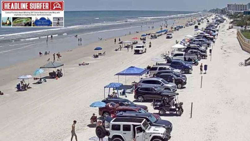
TOP: Flagler Avenue approach beach cam screenshot looking south at 1:30 pm Friday, May 16, 2025, in New Smyrna Beach, Florida.
LEFT: Dunlawton Avenue approach beach cam screenshot looking south at 1:31 pm Friday, May 16, 2025, in Daytona Beach Shores, Florida.
BELOW: Downtown Winter Garden street cam screenshot at 1:35 pm Friday, May 16, 2025, in Winter Garden, Florida.
By SERA KING / Headline Surfer
ORLANDO, Fla. -- Today is yet another picture-perfect sunny day here in Central Florida on a Friday afternoon - from Orlando, and across the I-4 corridor to Sanford and Daytona Beach.
What a remarkable turnaround from a week's worth of rainy days and overcast skies that ended on Wednesday.
The National Weather Service in Melbourne is calling for continued sunshine through Wednesday for Orlando and the rest of Central Florida, but daytime temperatures are increasing to the mid-90s. This afternoon will be sunny and hot, with a high near 96. The wind will be west-southwest, 5 to 10 mph. Tonight will be mostly clear skies, with a low around 72. There will be a west-northwest wind 5 to 10 mph.
The National Weather Service in Melbourne is calling for continued sunshine through Wednesday for Orlando and the rest of Central Florida, but daytime temperatures are increasing to the mid-90s. This afternoon will be sunny and hot, with a high near 96. The wind will be west-southwest, 5 to 10 mph. Tonight will be mostly clear skies, with a low around 72. There will be a west-northwest wind 5 to 10 mph.
Here is the extended weather forecast for Central Florida - from Orlando and along the I-4 corridor to coastal cities:
Saturday: Sunny and hot, with a high near 96. West wind 5 to 10 mph.
Saturday Night: Mostly clear, with a low around 73. West-northwest wind 5 to 10 mph.
Sunday: Sunny and hot, with a high near 96. Calm wind becoming west around five mph in the afternoon.
Sunday Night: Mostly clear, with a low around 75. Northwest wind around five mph, becoming west southwest after midnight.
Monday: Sunny and hot, with a high near 96. Calm wind becoming west southwest around five mph in the afternoon.
Monday Night: Mostly clear, with a low around 75. West northwest wind around five mph, becoming south southwest after midnight.
Tuesday: Sunny and hot, with a high near 97. Southwest wind around five mph.
Tuesday Night: Mostly clear, with a low around 75. West wind around five mph.
Wednesday: Mostly sunny and hot, with a high near 95. Southwest wind 5 to 10 mph, with gusts as high as 20 mph.
Wednesday Night: Partly cloudy, with a low around 75. West wind 5 to 10 mph.
Thursday: A 30 percent chance of showers and thunderstorms. Mostly sunny, with a high near 91. West wind around 10 mph, with gusts as high as 20 mph.
Multimedia video: Tornado season is above average & ramping up
 About the Byline Writer: