
 Photos for Headline Surfer /
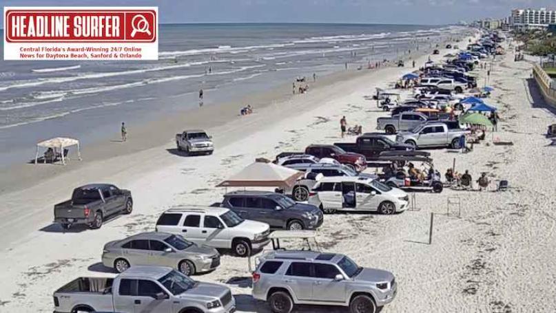
TOP: Beach cam screenshot from Flagler Avenue entrance ramp looking south at 4:20 p.m. Sunday, May 4, 2025, in New Smyrna Beach, Florida.
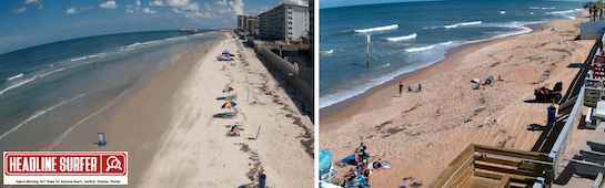
LEFT: Beach cam screenshot from Dunlawton Avenue entrance ramp looking south along Daytona Beach Shores, and beach cam in traffic-free zone on Ormond by-the-Sea in Ormond Beach, Florida. Both locations were captured around 4:20 p.m. Sunday, May 4, 2025.
By SERA KING / Headline Surfer
LAKE MARY, Fla. -- The early morning thunderstorm was quite loud for 10 minutes.
According to the National Weather Service in Melbourne, the Interstate 4 corridor from Orlando to the Atlantic shoreline should expect rain throughout the week and into the weekend.
Here's the extended forecast:
Tonight: A 30 percent chance of showers and thunderstorms, mainly before 8 pm. Mostly clear, with a low around 68. The west wind is around 5 mph and is becoming calm in the evening.
Monday: A chance of showers and thunderstorms before 4 pm, then showers likely and possibly a thunderstorm between 4 pm and 5 pm, then a chance of showers and thunderstorms after 5 pm. Mostly sunny, with a high near 89. Calm wind becoming south southwest around 5 mph in the afternoon. The chance of precipitation is 60% -- new rainfall amounts of less than a tenth of an inch, except higher amounts are possible in thunderstorms.
Monday Night: A 30 percent chance of showers and thunderstorms before 8 pm. Partly cloudy, with a low around 68. West northwest wind is around 5 mph and becoming calm in the evening.
Tuesday: A 30 percent chance of showers and thunderstorms after 2 pm. Sunny, with a high near 91. Calm wind becoming south southeast around 5 mph in the afternoon.
Tuesday Night: A 30 percent chance of showers before 8 pm. Mostly clear, with a low around 71. Southeast wind around 5 mph.
Wednesday: A 40 percent chance of showers after 2 pm. Mostly sunny, with a high near 92. South southeast wind around 5 mph.
Wednesday Night: A 30 percent chance of showers before 8 pm. Mostly cloudy, with a low around 71. Southeast wind around 5 mph.
Thursday: A 40 percent chance of showers after 2 pm. Mostly sunny, with a high near 91. South southeast wind around 5 mph.
Thursday Night: A 30 percent chance of showers and thunderstorms, mainly before 8pm. Mostly cloudy, with a low around 70. East wind around 5 mph becoming south southwest after midnight.
Friday: Showers likely and possibly a thunderstorm. Partly sunny, with a high near 89. South southwest wind 5 to 10 mph. The chance of precipitation is 60%.
Friday Night: Showers and thunderstorms are likely. It will be mostly cloudy, with a low around 69. The northeast wind will be around 5 mph, becoming southeast after midnight. The chance of precipitation is 60%.
Saturday: Showers and thunderstorms are likely, and some could produce heavy rainfall. It's partly sunny, with a high near 84. The southeast wind is 5 to 10 mph. The chance of precipitation is 60%.
The long-range forecast: East Central Florida is expected to see rain or mostly cloudy skies until Sunday, May 11, when sunshine will be abundant.
The long-range forecast: East Central Florida is expected to see rain or mostly cloudy skies until Sunday, May 11, when sunshine will be abundant.
 About the Byline Writer: