
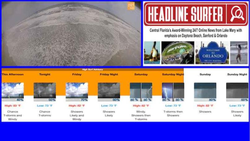
Headline Surfer photo illustration / TOP: A beach cam from the Dunlawton Avenue approach in Daytona Beach Shores, Florida, is shown, as well as a summary of the 7-day weather forecast for Daytona Beach, Florida, from the National Weather Service. BELOW: Live view of the Daytona Beach Shores beach cam is shown via YouTube download.
By SERA KING / Headline Surfer
DAYTONA. BEACH, Fla. -- Rain is in the forecast for East Central Florida -- from the coastal cities of Daytona to Orlando -- for the next seven years, according to the National Weather Service in Melbourne.
 The precipitation is fueled by tropical storms out in the Atlantic, which are causing rip currents along the East Central Florida shoreline, affecting Palm Coast, Flagler Beach, Ormond Beach, Daytona Beach, Daytona Beach Shores, Ponce Inlet, New Smyrna Beach, Cocoa Beach, and other nearby locations.
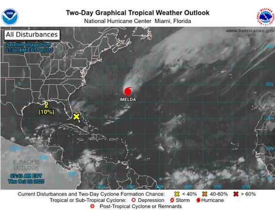
Graphic illustration from the National Hurricane Center in Miami, Florida.
Detailed Forecast:
This Afternoon: A 40 percent chance of showers and thunderstorms, mainly before 5 pm. Mostly sunny, with a high near 83. Windy, with an east northeast wind 15 to 20 mph, with gusts as high as 30 mph.
Tonight: A 50 percent chance of showers and thunderstorms. Partly cloudy, with a low around 73. East northeast wind around 15 mph, with gusts as high as 30 mph. New rainfall amounts between a quarter and half an inch are possible.
Friday: Showers likely and possibly a thunderstorm. Mostly sunny, with a high near 82. Windy, with an east northeast wind 15 to 20 mph, with gusts as high as 30 mph. The chance of precipitation is 70%. New rainfall amounts between a quarter and half an inch are possible.
Friday Night: Showers likely and possibly a thunderstorm. Partly cloudy, with a low around 73. East wind around 15 mph, with gusts as high as 30 mph. The chance of precipitation is 60%.
Saturday: Showers and possibly a thunderstorm. High near 82. Windy, with an east wind 15 to 20 mph, with gusts as high as 30 mph. The chance of precipitation is 80%.
Saturday Night: Showers and possibly a thunderstorm. Low around 73. East southeast wind around 15 mph, with gusts as high as 30 mph. The chance of precipitation is 80%.
Sunday: Showers and possibly a thunderstorm. High near 82. East southeast wind around 15 mph, with gusts as high as 25 mph. The chance of precipitation is 80%.
Sunday Night: Showers likely and possibly a thunderstorm before 2am, then a chance of showers and thunderstorms after 2am. Mostly cloudy, with a low around 73. East southeast wind 10 to 15 mph, with gusts as high as 25 mph. The chance of precipitation is 60%.
Monday: A chance of showers and thunderstorms, then showers likely and possibly a thunderstorm after 8 am. Partly sunny, with a high near 82. East wind 10 to 15 mph, with gusts as high as 25 mph. The chance of precipitation is 70%.
Monday Night: A chance of showers and thunderstorms. Mostly cloudy, with a low around 73. East wind 10 to 15 mph, with gusts as high as 25 mph. The chance of precipitation is 40%.
Tuesday: A 50 percent chance of showers and thunderstorms. Mostly sunny, with a high near 83. East wind 10 to 15 mph, with gusts as high as 25 mph.
Tuesday Night: A 30 percent chance of showers and thunderstorms. Partly cloudy, with a low around 74. East wind around 10 mph, with gusts as high as 20 mph.
Wednesday: A 40 percent chance of showers and thunderstorms. Mostly sunny, with a high near 84. East wind 10 to 15 mph, with gusts as high as 20 mph.
 About the Byline Writer: